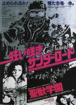
The Best of Sedona

The last time I passed through this area was almost ten years ago during my Route 66 road trip from Los Angeles to Chicago. Back then, I drove through Arizona so quickly that only the desert and cacti left me with some vague impressions as I passed through the city of Flagstaff.

Thanks to my friend’s good fortune, I had the chance to fly to Phoenix for the first time and venture north to explore more of the state, ultimately having one of my best backpacking experiences in a tiny village hidden inside the Grand Canyon.

While I will save my Havasupai trip for another post, I definitely want to spare some words to share my explorations in Sedona. In just one day, I managed to reach three different destinations around the Sedona area: the Subway Cave, the Birthing Cave, and Devil’s Bridge.

Having lived in the Pacific Northwest for 10 years, the landscape in Sedona was a striking contrast to me. The types of plants, the shapes of the mountains and rocks, the humidity of the air, and the strength of the sunshine all made a strong impression. I had almost forgotten that I hiked Angels Landing a couple of years before (pre-pandemic). Arriving at midnight, I was not aware of the drastic change in my surroundings until I woke up and pulled the curtains aside. The red rocks were so immense that even from afar, they immediately drew my attention with their unique shapes—something I would never find around Seattle.

The flyers in the hotel illustrated a lifestyle that was so different: ATV riding in the desert, helicopter tours into the valleys, stargazing at night, and absorbing cosmic energy while meditating. Indeed, it is believed that Sedona is a vortex where energy moves up or down in a spiral.

For us, though, without a lot of luxurious time to spare, my friend and I headed directly to the destinations on our list. All three destinations were easy to moderate hikes, but the views were quite gorgeous. It was a bit of a pity that the blue sky did not show up when we were at the Subway Cave; otherwise, the photos would have been more impressive. It was quite fascinating to imagine how water had shaped the landscape and then disappeared after completing its work, as well as those people who discovered these places and marked the way for future visitors. By the way, I was just shocked by my friend driving the SUV (Toyota 4Runner) on Dry Creek Road! Just do not attempt it unless you have a vehicle with very high clearance and are extremely confident in your skills!

The turquoise McDonald’s arch also earned a spot on our destination list. While the reasoning behind it, ensuring harmony with the natural colors of the landscape, was somewhat unconvincing, the uniqueness itself was worth a brief stop. Besides this, there are quite a few other places that I marked on the map for future visits, including the Chapel of the Holy Cross, Tuzigoot, Montezuma Castle National Monument, and the Gold King Mine & Ghost Town, among others.

10000 ft North Cascade Weekend Part II - Highway Cycling

This year, SR 20 the North Cascades Highway opened unusually early due to the increasingly warm weather. I had been planning this scenic cycling trip for years but was concerned about the road conditions and whether they would be suitable for my road bike. This time, I borrowed a gravel bike from a friend and finally made the trip!

The trailhead felt like a party. The parking lot was packed, and the highway shoulder was lined with vehicles. The entire trip route from Ross Dam Trailhead to the Washington Pass sign spanned roughly 60 miles with an elevation gain of 5,000 feet. We maintained a relaxed pace and finished just before a beautiful sunset.

The entire route was easier than I had anticipated. Although there were multiple passes to cross, the inclines were manageable. When riding back, you can imagine how it felt to descend 4,000 feet.

Riding in the center of the highway, enjoying the full width of the road, was a unique experience. The views were just gorgeous. And it turned out there were not as many tiny rocks or dirt patches as expected, so a road bike could have easily handled it.

Our final stop was just past Early Winter Spires at the roadside view of Washington Pass. I’m grateful for all the hard work done to clear the route, providing us cyclists with this once-a-year opportunity.

10000 ft North Cascade Weekend Part I - Hidden Lake Touring

This year’s severe snow conditions have closed off many backcountry destinations. Meanwhile, Highway SR 20 opened on one of its historically earliest dates. After a much shorter resort season, I enjoyed a very busy weekend. According to my Google Maps notes, it seems that I had been to Hidden Lake Peak and the lookout a long time ago, but I can’t remember any details.

The length and elevation gain of the Hidden Lake Peak route were relatively moderate—roughly 7 miles and 4,000 feet, so fortunately, no alpine start was needed for a one-day trip from Seattle.

Driving north, the view to the right featured the morning mist accumulating in the Snohomish Valley. Far in the distance, Mount Pilchuck was prominent to the east. After turning right towards Darrington, Whitehorse Mountain loomed next to the town.

After crossing the Marblemount Bridge, we headed towards the center of the North Cascades. The last time I was here was probably during an attempt to climb Eldorado Peak. My list of destinations definitely grows much faster than my ability to check them off.

It was mid-April, and the unpaved road was snow-free almost up to the Hidden Lake trailhead. In a day or two, the trailhead would be completely free of snow. Naturally, the approach took about an hour before we began to skin up.”

After another hour or two, we arrived at the ridge of Hidden Lake Peak, approximately 6,200 feet in elevation. Before heading up to the summit, there was a bit of drama when a friend accidentally dropped one of his skis. The ski brake wasn’t released or leashed, and it shot down into the gully, disappearing from sight. Just when we thought we might have to end our day early, someone surprisingly found it and carried it back up! We were incredibly lucky to have someone find and return the ski.

Having retrieved the ski, we didn’t need to give up our summit plans and continued to hike up. The next 1,000 feet of elevation gain was much more straightforward. Eventually, we summited Hidden Lake Peak. The view was gorgeous, and the hidden lake, now fully unveiled before us, was frozen.

The ride down mostly followed our ascent route, although we enjoyed some better turns on the upper part of the mountain. Due to the extreme heat, the snow became extremely dense after dropping below 6,000 feet. When we got back to the car, the snowpack had significantly retreated from our morning footprint.

This time, we did not visit the lookout. The route to the lookout was a bit further from the summit route. We saw a group planning to stay there, which might be my next plan. The alpine glow and the cozy hut are definitely worth a trip!